Back to Elsinore : Cross Country / Vol Voyage
May 2, 2004 : E Launch à Santiago à Home in San Clemente
by Jérôme Daoust.
|
|
|
Blue curve shows the course taken. The red star indicates Santiago Peak. |
I got there early with Bob Barry to see how the conditions would evolve. Soaring forecast was predicting 4250 m (13900') MSL. Predicted wind at altitude would be SE, not good for going XC to the East as on a typical day after the convergence happened and on-shore flow prevailed. On arrival, the wind steadily flowed in, but later became lighter and less regular, even with some light downwind cycles.
|
|
|
Picture of myself on the E- launch, taken by Bob Barry. Click on picture for full size image. |
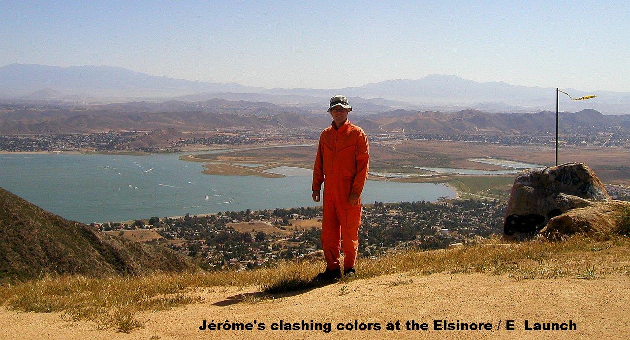
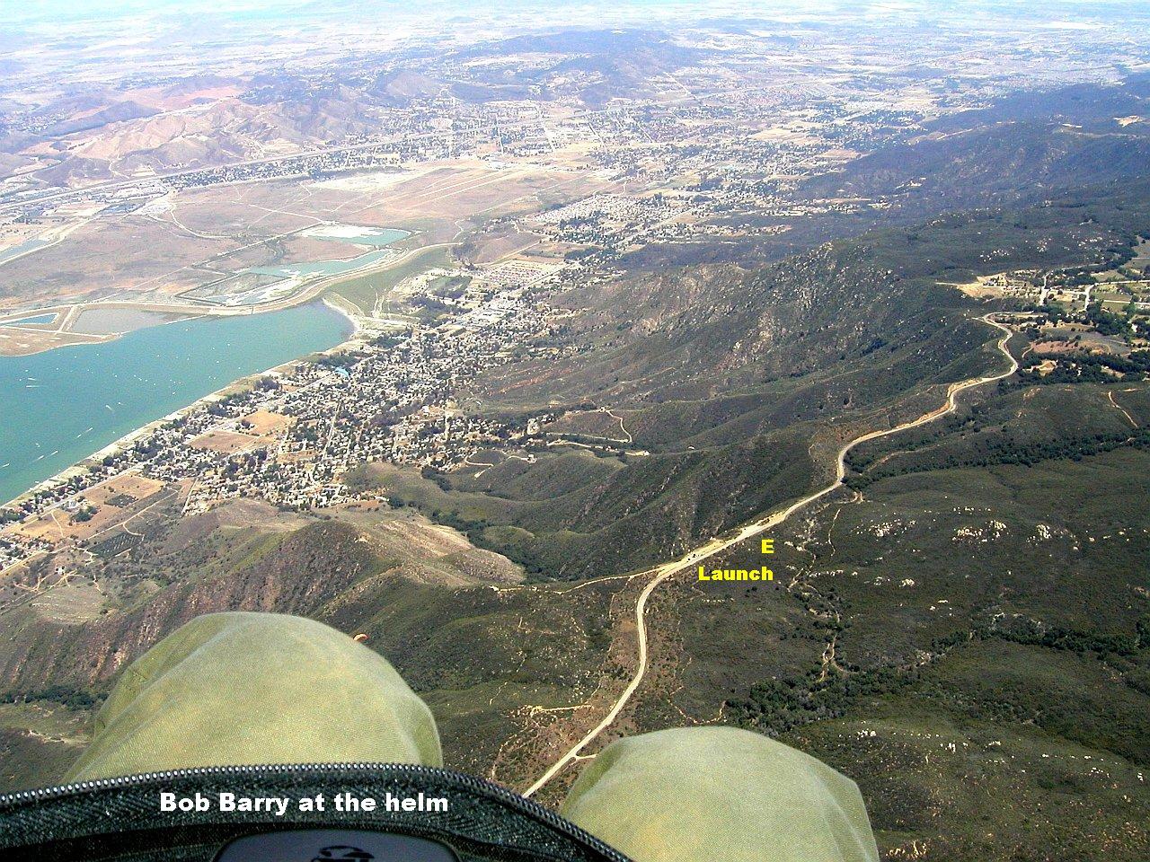
The first few pilots who launched, had challenging conditions and some had to head for the LZ. Local PG pilot John launched and was making altitude gains. In a quick maneuver, I left the PG group on the new left side launch and shuffled to the far right of old HG launch to start setting up on a flat. Using a good cycle I stabilized the wing and launched in front of a high bush (I told you this wasn't a normal launch area) and cleared it with some scraping.
The first 300 m (1000') gain was made through tight punchy lift, 7/10 on my turbulence scale. But above that, lift became organized and enjoyable. Got to 1200 m (4000') above launch.
|
|
|
Picture of the E- launch area, taken by Bob Barry. Click on picture for full size image. |
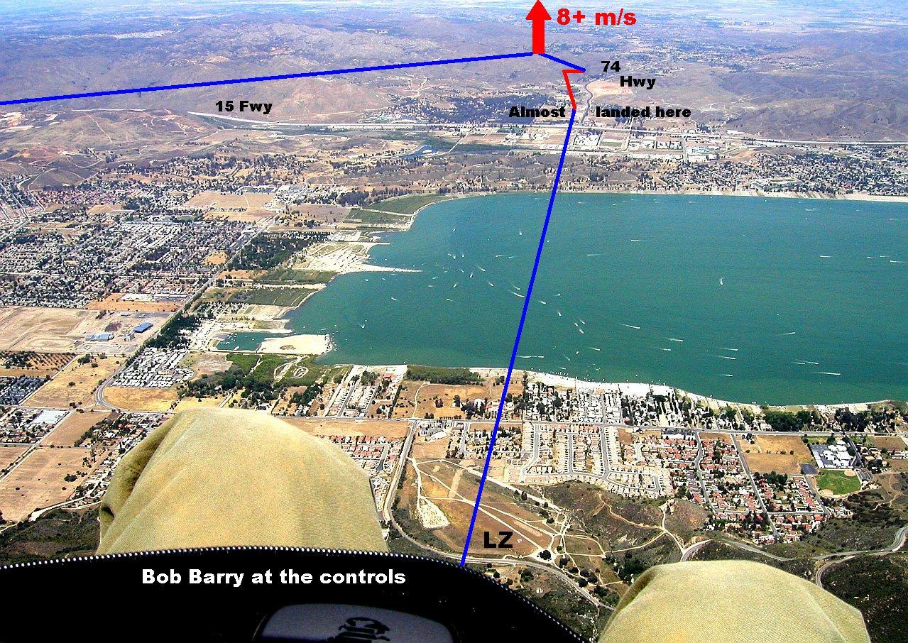
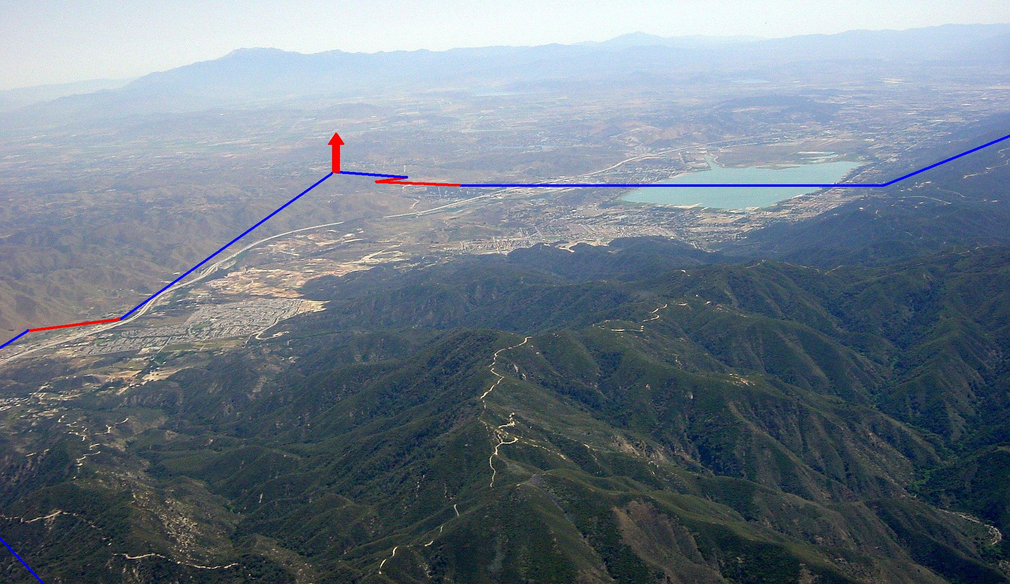
Crossed the lake, got very low [150 m (500') AGL] on other side of the 15 Fwy next to Ortega (74) Hwy while others where now sky-ing out over Elsinore up to 4000 m (13100') MSL. I didn't feel too wise at that moment. But I found a weak thermal and stuck with it, loosing it twice and finally abandoned it at 450 m (1500') AGL to head a bit further East into the low hills. There I found some healthy 8+ m/s (1600 fpm) up to a max altitude of 3950 m (13000') MSL, with a pause ¾ up the way'. Nice thermal quality (smooth edges) despite the high climb rate.
|
|
|
Picture of Lake Elsinore, taken by Bob Barry. Lines show my course over the ground, with blue being on glide and red in lift. Click on picture for full size image. |
My bare hands got very cold, so as my body only covered by a single thin layer of cotton. But that is a sure way of getting high : Do no dress for high altitude. I started gliding towards the east and put on my pair of gloves. After the gloves were on I notice I had made almost no progress towards the East, and there thermal drifted me towards the NW. I wish I had a GPS to know my ground speed. I asked for advice over the radio on possible routes. Following the 15 North was recommended and adopted.
From about 2750 m (9000') MSL over the 15 Fwy with Santiago Peak to my left of the Freeway, I got another smooth climb up to 3950 m (13000') MSL. Now everything was clear : I will fly into Orange County and cross over Santiago Peak which is at 1734 m (5687') MSL. I relayed my plan over the radio to Bob who was on his way up to retrieve his vehicle on launch. The idea was to land where I did a week ago when launching from Santiago Peak, into a park in Rancho Santa Margarita, at the end of Antonio Parkway. While on glide to Santiago Peak, I leaned forward and felt my back turn icy cold from the cold air whisking away perspiration. Soon after I started shaking from the cold.
|
|
|
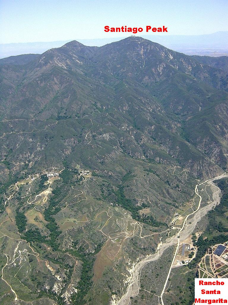
Picture of Lake Elsinore area, taken by myself a week earlier, when at 3050 m (10000') MSL at Santiago Peak (I had launched from there). This time I would cross over the Santiago Peak higher than this. Lines show my course over the ground, with blue being on glide and red in lift. Click on picture for full size image. |
Easy glide over Santiago Peak with 1900 m (6200') of clearance, then over the previous week's LZ at 3350 m (11000') MSL. No idea what to do next but I was happy and reported my position over the radio. I goofed around for a while with a general South heading to explore the terrain.
|
|
|
Picture taken by myself a week earlier, of Santiago Peak (I had launched from there). Click on picture for full size image. |
Then my XC brain took over as my body started warming up again. I know Bob would be driving up Antonio Parkway so why not see how far South I could fly towards Ortega (74) Hwy ? I proceeded why keeping possible LZ within glide : Golf course, big play field, new housing development. I was surprised how good the glide I was getting, but what I failed to realize at the time is that the terrain was sloped down towards the beach, providing the optical illusion of a good glide over flat terrain.
|
|
|
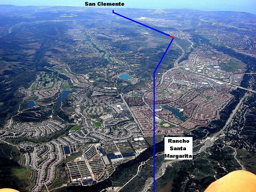
Picture of the final leg, taken by myself a week earlier, when at 3050 m (10000') MSL at Santiago Peak (I had launched from there). Lines show my course over the ground, with blue being on glide and red in lift. Click on picture for full size image. |
When I reached Ortega (74) Hwy, Bob and Roger where getting close, and I relayed my position. I think it was Roger, which first spotted me. At that time I looked further and recognized the Prima Deschecha Landfill, which I knew, was close to my house. Looking yet further I could not believe what I saw : That is the park next to my house, where I kited my wing ! This is home ! I live just up the street from there. The temptation of reaching the park was huge. If only I could pass the landfill hump.
I told Bob and Roger I was going for home, with possible landing in the landfill. I was no obvious at all if I would pass, but no big deal as I could hike down to the park if I did not. Got a bit of lift as I negotiated a curved path to avoid the top of the landfill and then it happened : I knew I was going to make the park. What a great feeling. Landing in the park was a tight fit, but uneventful. Only one minivan driver noticed my arrival and waived. A stealthy approach.
First thing I did after taking my helmet off was to get my wife on the phone, to come over and share this joyous moment. In the park the wind was from changing directions a lot, even had a good downdraft at one point. My wife met me just in time for folding. Bob and Roger arrived just by the time I finished packing.
But what to do after this ? The answer was easy : Order Pizza at my place. Roger twisted my arm and took care of the bill.
The Numbers
3 hours of airtime.
Distance (E launch à 15 Fwy x Ortega (74) Hwy à Santiago Peak à San Clemente) is 65 km (40 miles).
Straight-line distance (E launch à San Clemente) is 29 km (18 miles).
The Memories
This flight would have been a GREAT flight in itself, but landing at the park near my house, pushed it into the MAGICAL category. Landing at your house adds something that cannot be measured in distance. What just happened is that I brought paragliding home into my everyday life. Two things, which are not normally connected. I became very distracted, as if I had Attention Deficit Disorder for the rest of the day. I felt like a kid. What just happened was just starting to sink in, more time would be needed for that. The next morning on my way to work from my street, I looked at the park and told myself : That's where I landed, and just had to smile.