Flying site / Site de vol
Blackhawk, California, USA
Jérôme Daoust
( E-mail )
2025/1/20
-
Conditions
-
The club supporting the site / Le club supportant le site :
No info.
-
Events / Evénement :
CSS-Forum-Road Trips.
-
Bulletin board / Tableau d'affichage :
No info.
-
Articles
-
Schools / Ecoles
-
Lost and Found / Object perdu ou retrouvé :
CSS-Forum-Lost&Found.
-
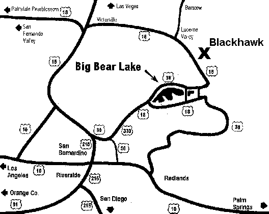
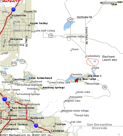
How to get there / Comment s'y rendre
-
Maps / Cartes
-
GPS coordinates / Coordonnées GPS
-
Site frequency / Fréquence du site :
146.415 .
-
Insurance / Assurances
-
Lodging / Hébergement
-
Restaurant :
No info.
-
Car rental / Location d'auto :
No info.
-
Image
-
Video or Animation / Vidéo ou Animation
-
Cross Country / Vol Voyage
-
Hazards / Dangers
Conditions
We are hoping for light NNE (22°) winds, although launch faces NE (45°).
By order of interest :
-
Forecast :
-
Windgram, for wind direction and altitude ceilings:
Soaring Predictor
(click "Blackhawk",
Archive).
Understanding "Wind Barbs".
Alternate website(s):
FlyMarshall.
-
RASP (Regional Atmospheric Soaring Predictor) for Southern California:
Soaring Predictor
(Older version).
Typical sequence:
-
Select day and time.
-
Select a parameter like "Sfc.Wind (10m)".
-
To change the opacity of the data layer:
Click the "+" or "-" icons in lower right
(Old version: Use slider in the upper right, or mouse's center wheel).
-
Finding flying sites:
Click the layer icon in the upper right, enable the "Sounding/SkewT".
Hover your mouse pointer over the markers, names appear.
Alternate website(s):
FlyMarshall.
-
Lucerne Valley forecast (Weather Underground):
Hourly,
10 days.
-
Lucerne Valley forecast (Weather.com):
Hourly,
15 days.
-
Soaring Predictor: Detailed Predictions
(updated daily at 7:30 AM).
-
Typical optimistic altitude ceilings, Windgram closer to reality.
-
Look for a fire nearby (associated air traffic):
-
Look for a TFR (Temporary Flight Restriction):
-
SkyVector.
-
SoaringData. Transforms local TFRs into a KML file for visualization in Google Earth:
-
Center airport identifier: sbd (San Bernardino International)
-
Bounding radius (stat. miles): 100
-
Airspace in Google Earth KML format
-
Append special use and ATC-controlled airspace uncheked
-
Type "Soar" into this box: Soar and press Submit
-
SoarCal / TFR. Click the map icon to visualize the TFR over a map.
-
FAA / TFR. Set "State" to "California", then click "GO" next to it.
-
Current :
Articles
Schools / Ecoles
for paragliding operating at this site.
Ordered alphabetically / Ordonné alphabétiquement:
How to get there / Comment s'y rendre
You need a 4x4 vehicule to get to launch.
With a 2 wheel drive vehicule, you have a 75% chance of reaching launch,
but will damage the roads in the difficult areas,
increasing the risk that rangers shut us out of the site because of road abuse.
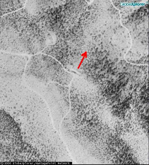
Maps / Cartes
-
Google Earth:
Local points of interest.
A great way to explore this flying site in 3D.
-
Google - Satellite:
Launch.
You can drag the map with your mouse.
GPS coordinates / Coordonnées GPS
| Description |
Latitude |
Longitude |
Altitude (ASL) |
| Launch |
N 34° 20.579' |
W 116° 49.150' |
1920 m |
6298' |
| Hwy 18 : Start of dirt road to launch |
N 34° 21.106' |
W 116° 50.793' |
|
|
For a great way to explore this flying site in 3D,
see Google Earth's Local points of interest in the
Maps section.
Insurance / Assurances
-
You will need to become a USHPA member and it's not expensive
for the 1 month membership.
Just contact one of the
Schools
so you can take the one month membership for 10$.
It is good all over the US for the 30 day period.
-
Tu devras devenir un membre de l'USHPA et ce n'est pas cher
pour être membre pour un mois.
Tu as juste à contacter une des
Ecoles
afin de prendre le membersip d'un mois pour 10$.
Ce sera bon pour tous les sites aux Etats-Unis pour une
période de 30 jours.
Lodging / Hébergement
-
Campings
in the San Bernardino National Forest
Image
Pictures I took (click thumbnail to open full size image in a new window)
Photos que j'ai prises (clique la petite image pour ouvrir la photo pleine grandeur dans une nouvelle fenêtre)
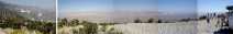
|
2001/8/25
|
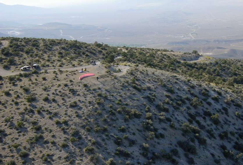
Panorama from launch.
|
|
Panorama depuis le décollage.
|

|
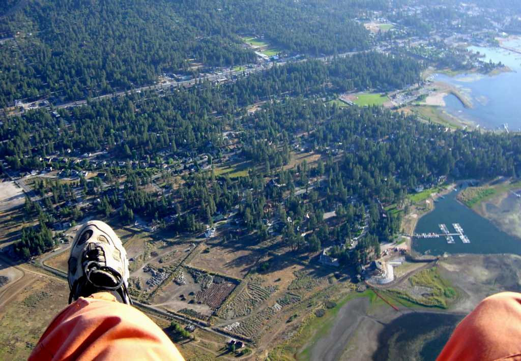
2001/8/25
|
Looking at launch while flying by.
|
|
Regardant le décollage en passant devant.
|

|
2001/8/25
|
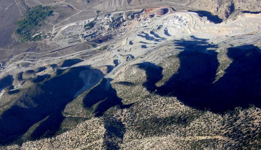
Above 1st quarry to the West of launch.
|
|
Au-dessus de la 1ère carrière
à l'Ouest du décollage.
|

|
2001/8/25
|
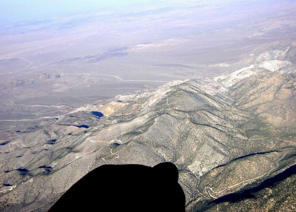
Looking at launch from the West at 2700 m (8800') MSL.
|
|
Regardant le décollage depuis l'Ouest à 2700 m (8800') MSL.
|

|
2001/8/25
|
Looking at launch from the West at 3370 m (11000') MSL.
|
|
Regardant le décollage depuis l'Ouest à 3370 m (11000') MSL.
|

|
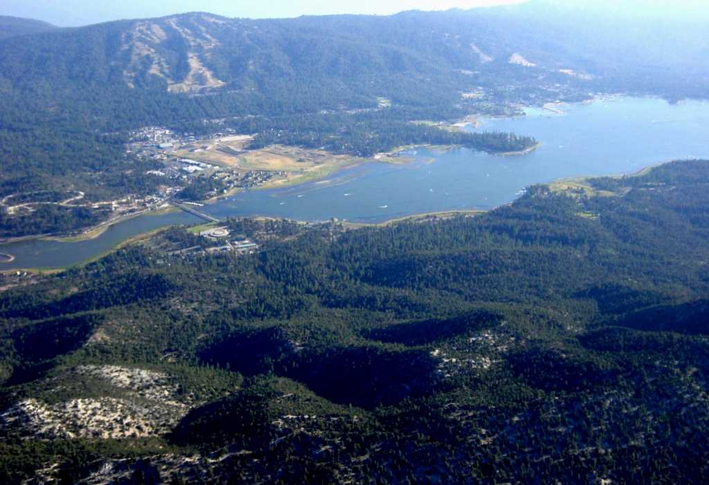
2001/8/25
|
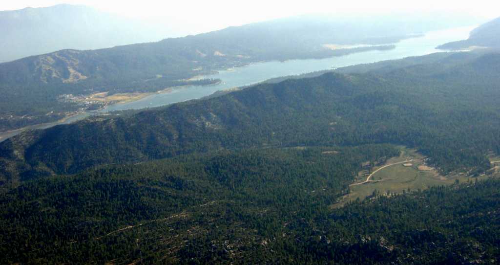
Looking at Big Bear lake from above 1st quarry
to the West of launch, at 3370 m (11000') MSL.
|
|
Regardant le lac Big Bear depuis au-dessus
de la 1ère carrière à l'Ouest du décollage,
à 3370 m (11000') MSL.
|

|
2001/8/25
|
Halfway towards the East end of Big Bear lake.
|
|
A mi-chemin vers l'extrémité Est du lac Big Bear.
|

|
2001/8/25
|
Over the East end of Big Bear lake.
|
|
Au-dessus de l'extrémité Est du lac Big Bear.
|
Video or Animation / Vidéo ou Animation
None.
Cross Country / Vol Voyage
Before you go, know your airspace. For Google Earth:
California 3D overlay for classes B/C/D and restricted military airspace.
-
South-West :
-
West :
-
I fly to Hwy 18 and Milpas Drive (2001/8/11) : 29 km.
I did a forward launch in the light wing and hugged the ridge to the left until I found a spot
where I could maintain, and gain slowly.
Very shortly after, a swarm of other wings were buzzing close by.
After gaining about 330 m (1100') over launch,
I crossed Highway 18 and found the big one !
A climb of 2640 m (8700') over launch.
I recorded an altitude of 4560 m (15000') while under cloudbase.
2.5 hours and a couple of thermals later, I was landing 29 km (18 miles) to the West
limited in my progress by the arrival of the ocean breeze.
The air was smooth throughout the flight.
Nice 3-4 m/s climbs, right in my comfort zone.
-
Tom Truax flies to South of Rodgers Dry Lake (2001/8/6) : 98 km.
-
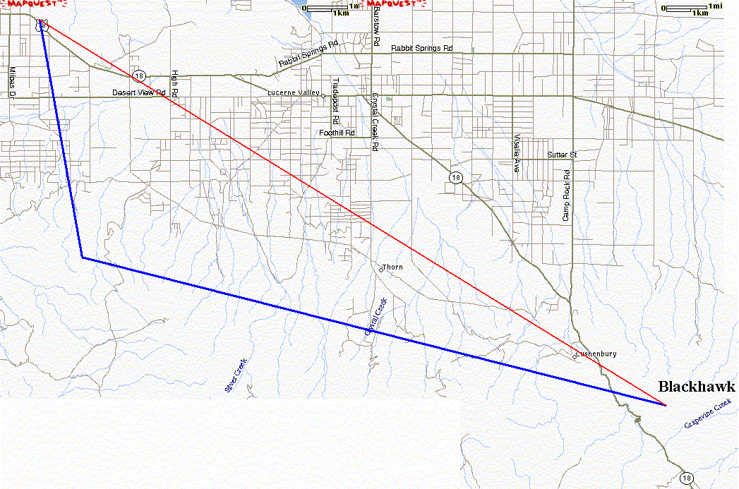
North-West :
Recovery road map (301 kB).
Printing on 11"x17" sheets, will produce fine print but will still have readable street names.
Send in your pictures and articles...
Hazards / Dangers
-
Low population density in front of launch.
-
Faible densité de population en avant du décollage.

