Back to Articles on Accessories / Articles sur les
Accessoires.
Google Earth
Review by Jérôme Daoust. Created
2005/6/29, revised 2009/2/17
1.
Google Earth
1.3.
Becoming a supplier of KMZ files
2.
Resources
2.1.
GPS flight recovery
2.1.1.
Generic GPS
2.1.2.
Bräuniger/Competino
2.2. Convert IGC file to a KML
format
2.2.1.
Paragliding Earth
2.2.2.
GPSBabel
2.2.3.
e-ality
2.2.4.
IGC2GoogleEarth
2.2.5.
Leonardo
2.2.6.
GPS Visualizer
2.2.7.
Richard Hunt
2.2.8.
Fly Arena
2.2.9.
IGC to KML
2.3. Convert IGC file to a GPX
format
2.3.1.
GPSBabel
2.3.2.
GPS Visualizer
2.4. Google Earth to a Garmin
GPS (USB)
2.4.1.
Transfer a Waypoint
2.5. Flight Replay
2.5.1.
IGC Flight Replay
Install
Google Earth, if not already done:
- Webpage: http://earth.google.com
|
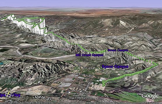
Example
of a flight I did: Equivalent KMZ file (to
launch Google Earth to view it) |
|
|
- Input
required: KML file.
- Double-click the KML file,
it will launch Google Earth, and also put your flight data into the
"Temporary Places"
- Save your flight data:
- Expand the tree under
Temporary Places / GPS Device
- Drag the "Track"
item to under "My Places"
- Right-Click the moved
"Track" item and select "Edit":
- Give it a name like "2005_04_16_Marshall_TO_Yucaipa".
- Enable the
"Advanced" option.
- Click the
"Location" tab.
Change
from "Clamped to ground" to "Absolute".
Optional:
If you want to see vertical elevation lines: Enable "Draw lines
connecting points to ground".
- Click the
"Custom" button near the Top+Right of the form.
Select
the first green circle icon.
- Click the
"Style" tab.
In
the "Icons" group, change the scale from 1.0 to 0.2 .
o Close the form, by clicking
"OK".
- Manipulate the view.
Ground shadow display
- Input
required: GPX file.
- Launch Google Earth
- Input your file:
- File: Open
- Filter for files of type
"Gps (*.gpx *.loc)"
- Select your file, click
"Open".
- Save your flight data:
- Expand the tree under
Temporary Places / GPS Device
- Drag the "Track"
item to under "My Places"
- Right-Click the moved
"Track" item and select "Edit":
- Give it a meaningful name
like "2005_03_06_Torrey"
- Enable the
"Advanced" option.
- Click "Share
Style".
- Icons File/URL: Empty
out this field. Icons will disappear when you click in another
field.
- Lines: Change the color/width
to your preference (Red, Width=3).
o Close the form, by clicking
"OK".
- Manipulate the view.
Becoming a
supplier of KMZ files
If you are hosting *.kmz files under your website (like
I started doing), then users may have a file un-compression utility (like
WinZip) intervene when they follow the link to your
*.kmz file. Gerry Grossnegger supplied this valuable fix…
|
Your web server needs to know what
to tell your browser those files are, depending on their extensions. If your web host uses the Apache server
program, put these lines in your /.htaccess file: ErrorDocument 404
/errorpages/sn404.html AddType
application/vnd.google-earth.kml+xml
.kml ß
add this line AddType application/vnd.google-earth.kmz .kmz ß add this line |
GpsDump
- Web page: http://www.gethome.no/stein.sorensen
- Procedure
to download a flight from a Bräuniger/Competino.
Getting the IGC file of your flight:
Convert IGC
file to a KML format
- Install GPSBabel if not
already done:
- Webpage: http://www.gpsbabel.org
- Double click the "GPSBabelGUI"
application.
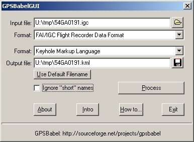
- Input File:
- Select file with a free
format (*.*) filter.
- Format: FAI/IGC Flight
Recorder Data Format
- Output file:
- Format: Keyhole Markup
Language
- Click "Use Default
Filename"
- Add the missing
"kml" extension
- Click "Process"
- Close the application
- You will be able to use
without installation the e-ality converter:
- Webpage:
- http://www.e-ality.de/i2ge_e (English)
- http://www.e-ality.de/i2ge (German)
- Steps (English version):
- Click
on the button that says Convert
IGC file it will pop up a small window for selecting your .igc file
- Click
on Browse... to find your file
- Click
on Upload and convert file… to
make the conversion.
- Click on Your KML File for Google Earth...
where you can download your .kml file.
- If
you have more files to convert, click on Convert another file…, or click on Close to close the window.
- Steps (German version):
- Click
on the button that says IGC Datei Konvertieren it will pop up a
small window for selecting your .igc file
- Click
on Browse... to find your file
- Click
on Datei übertragen und konvertieren... to make the conversion.
- Click on Ihre KML-Datei für Google Earth
where you can download your .kml file.
- If
you have more files to convert, click on Weitere Datei konvertieren...,
or click on Schließen to close the window.
- Stewart Midwinter writes:
- One more tip: if you used
something like MaxPunkte to generate your .igc file, then it should
contain your name and glider type (otherwise you can open your .igc file with
any text editor and add them - but beware, that will break your 'G'
security record. That pilot data will be nicely displayed in GE so that
you can readily identify your flight.
- Website: http://www.hgs.at/igc4google
- Website:
http://www.mycloudbase.com/google
IGC to KML, by Maddy Household
- Website:
http://www.maddyhome.com/igc2kml
Convert IGC file to a GPX format
- Install GPSBabel if not
already done:
- Webpage: http://www.gpsbabel.org
- Double click the
"GPSBabelGUI" application.
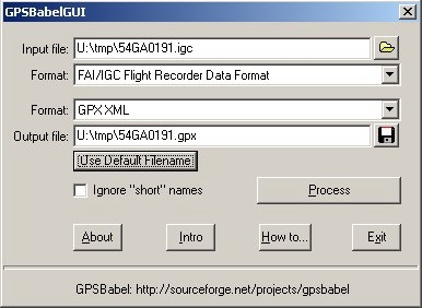
- Input File:
- Select file with a free
format (*.*) filter.
- Format: FAI/IGC Flight
Recorder Data Format
- Output file:
- Format: GPX XML
- Click "Use Default
Filename"
- Click "Process"
- Close the application
Google Earth to a Garmin GPS (USB)
- From
Google Earth:
- Select your placemark, then do "Save As…"
and save it as a KML file (not KMZ).
- Install GPSBabel if not
already done:
- Webpage: http://www.gpsbabel.org
- Connect
your GPS with the USB cable and turn it ON.
- Double click the
"GPSBabelGUI" application:
- Select "Google Earth
(Keyhole) Markup Language" as the input format.
- Select the KML file you
created from Google Earth.
- Set the output format to "Garmin serial/USB
protocol" and "USB" as the port.
- Click "let's go"

·
Website:
http://www.ywtw.de/igcsimen.html
·
Discussion:
http://www.paraglidingforum.com/viewtopic.php?t=16045
|
If you enjoyed reading this
review, please make a donation
to encourage me to write future reviews. |